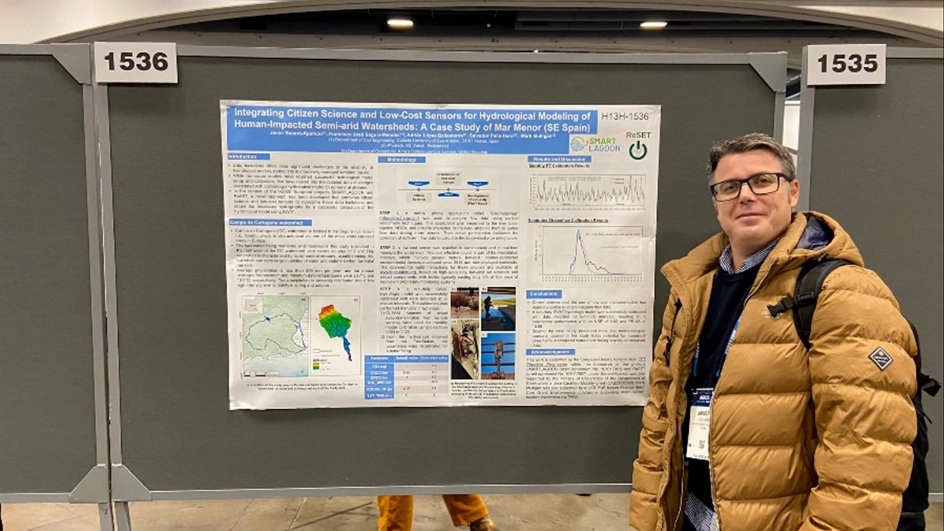
Validation of the hydrographic model of the SMARTLAGOON project in a riverbed in the Campo de Cartagena
Currently, the accurate measurement of the variables necessary for hydrological modeling faces the challenge of costly models and sensors. This problem is aggravated in basins with high water stress where monitoring is more complex. Such is the case of Campo de Cartagena, characterized by ephemeral streams and average annual rainfall of less than 300 mm. To address this situation, we implemented an innovative methodology that combines citizen science, through a mobile application that is able to obtain flow rates from recordings taken by citizens at specific control points; in addition to low-cost high-tech sensors capable of measuring the height of the water sheet, thanks to...
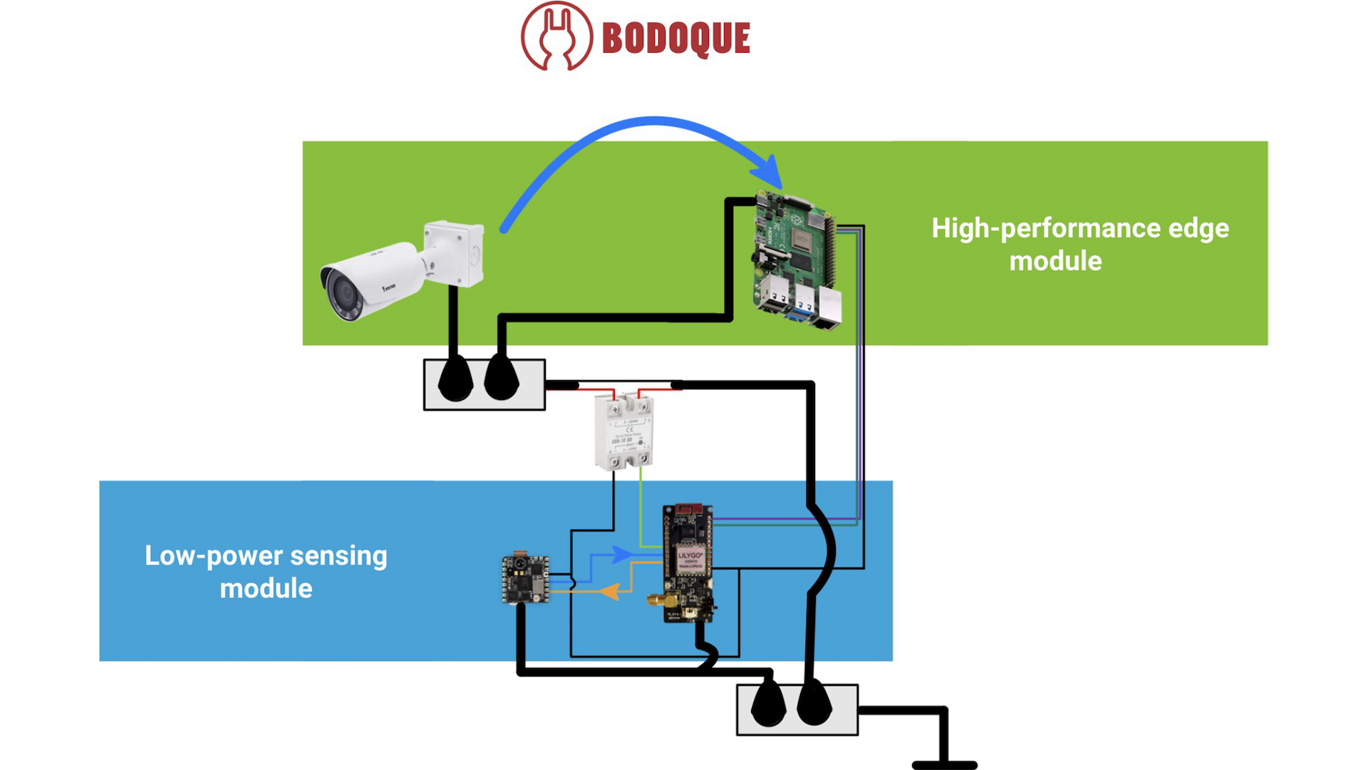
BODOQUE: An Energy-Efficient Flow Monitoring System for Ephemeral Streams
Effective environmental monitoring is crucial for managing global environmental challenges and providing the necessary data for Environmental Intelligence (EI). This discipline involves the integration of data from various sources to gain a comprehensive understanding of specific regions or processes. In this post, we introduce BODOQUE, a hardware-software infrastructure to monitor water flows in ephemeral streams where the water rarely flows with great force. BODOQUE uses a low-power TinyML-based camera to detect the presence of water, activating a more complex system to measure flow only when the water flows, thereby optimizing energy consumption. This device is being deployed in the Segura basin, Murcia, Spain. This...

Image-based turbidity measurements
The objective of the SMARTLAGOON project is to develop a digital twin of the Mar Menor and its entire watershed. It is intended to give real-time insights of the state of the Mar Menor, and also forecast the risk of hypoxia in the short-term future. The digital twin integrates water quantity and quality models and real-time sensor data. Regarding the real-time sensors, at SMARTLAGOON photrack is developing methods to measure turbidity via images. Water clarity can be used as in indicator for water quality assessment, its spatio-temporal monitoring is important for water management, and environmental protection of aquatic ecosystems. There are available sensors which can measure...

Satellite Imagery Approach in the H2020 SMARTLAGOON Project
Are you familiar with the products of the European Space Agency's (ESA) Copernicus programme? We are using both Sentinel-3 (S3) and Sentinel-2 (S2) in SMARTLAGOON because we are interested in using the almost daily remotely sensed water quality data to calibrate our Mar Menor lagoon model, which is provided by S3, but unfortunately at a very low resolution - i.e. 300 m pixels. We realised that in such a context, in a shallow water lagoon, there is a clear relationship between aerial images - such as those provided by S2 every 5-10 days and with a resolution of up to 10 m pixels - and...

Into the Depths: Exploring Mar Menor’s Virtual Counterpart
In 2019, a massive fish kill was reported from the iconic Mar Menor – likely a result of prolonged water column stratification and a long period of hypoxia (low oxygen levels) in large parts of the lagoon. Stratification, where the water column "divide" into distinct layers of density due to different temperatures or salinity, can oftentimes result in low or even completely depleted oxygen levels near the bottom. Even if these stratification events are short-lived (e.g. a few days or less), as is typical in shallow systems, such as Mar Menor, this can still be enough to cause low oxygen levels near the bottom....

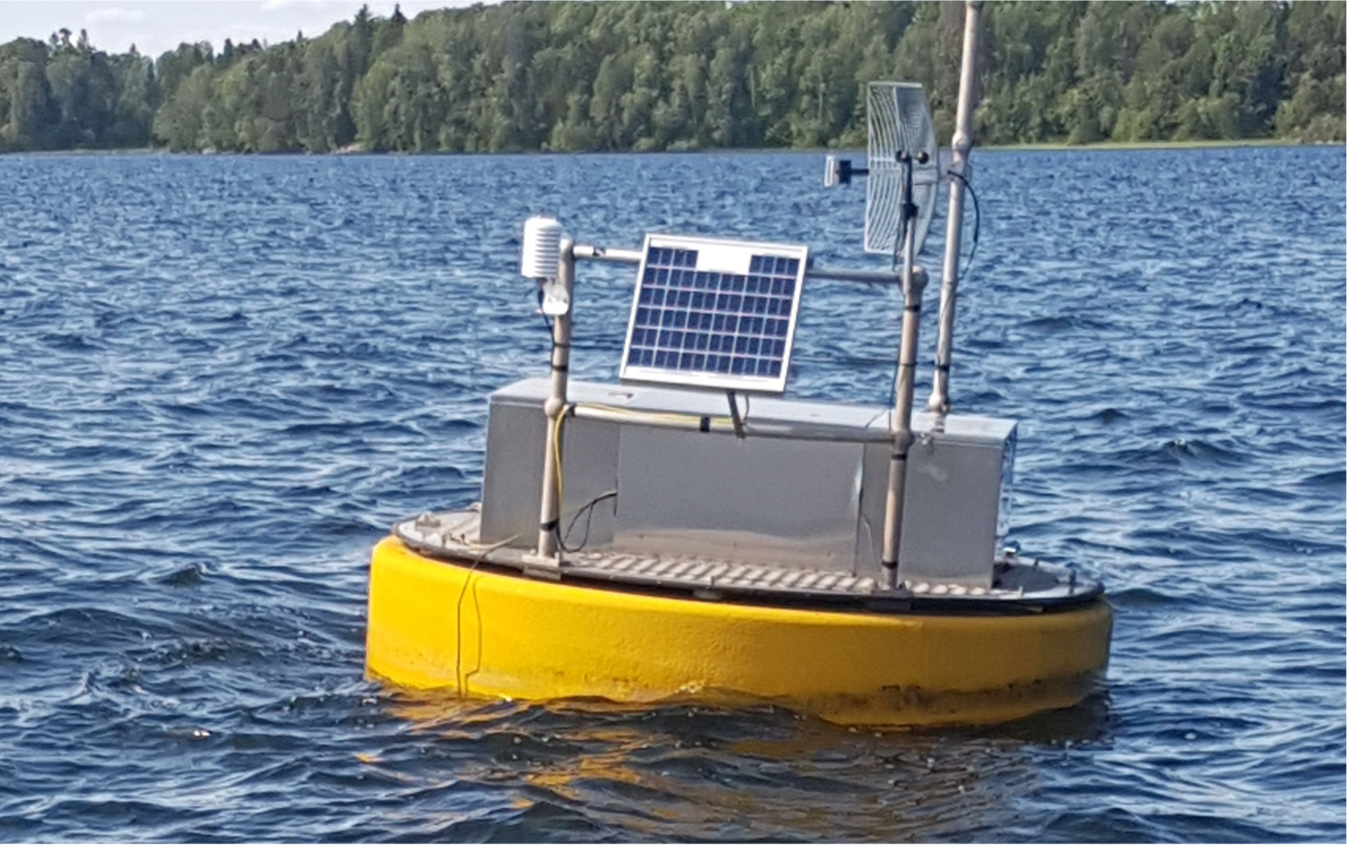
Deployment of the SMARTLAGOON oceanographic buoy in the Mar Menor
Last Friday 14th October 2022 was a relevant milestone for our project and we wanted to share with you our experience and first impressions after more than one month of operation. The SMARTLAGOON buoy electronics were designed, tested and developed by our partners from the Department of Ecology, Genetics and Limnology at Uppsala University in Lake Erken (Sweden). High-frequency monitoring activities have been carried out on this lake since the 1980s-90s, led by Dr. Don Pierson. In fact, since 1940, Lake Erken has served as a field station for research and teaching activities for researchers and students of Uppsala University (USA), becoming a limnology laboratory...
Despliegue de la boya oceanográfica de SMARTLAGOON en el Mar Menor
[For the English version -> LINK] El pasado viernes 14 de octubre de 2022 fue un hito relevante para nuestro proyecto y queríamos compartir con vosotros nuestra experiencia y primeras impresiones después de más de un mes de funcionamiento. La electrónica de la boya de SMARTLAGOON fue diseñada, testeada y desarrollada por nuestros socios del Departamento de Ecología, Genética y Limnología de Uppsala University en el Lago Erken (Suecia). En este lago se desarrollan actividades de monitorización de alta frecuencia desde los años 80-90, lideradas por el Dr. Don Pierson. De hecho, desde 1940 el lago Erken ha servido como estación de campo para desarrollar actividades...
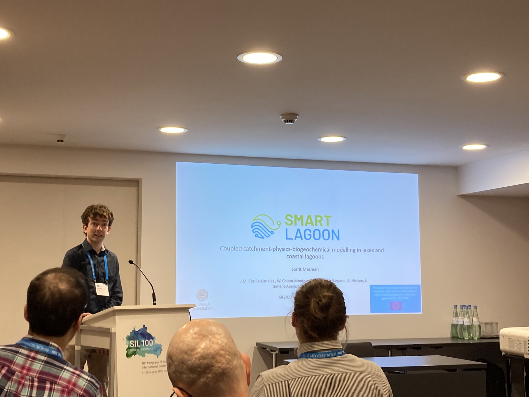
SMARTLAGOON represented at scientific meetings: DSOS and SIL
In July and August 2022, Jorrit Mesman represented SMARTLAGOON at two scientific events; the virtual DSOS (Data Science Open Science) Summit and the SIL (International Society of Limnology) conference in Berlin, Germany. Our project is composed of scientific knowledge and expertise that has been built-up over the past decades, but SMARTLAGOON also generates new knowledge that may benefit the larger scientific community, and therefore it is good to occasionally share this knowledge at scientific meetings. Moreover, by listening to and interacting with other scientists, new insights may be gained that can further help to achieve SMARTLAGOON’s goals. DSOS is a virtual event that intends to...
Intelligent environmental infrastructure
To collect real-time data about the lagoon, we are deploying an intelligent environmental infrastructure made of sensors and cam-eras. An intelligent environmental infrastructure can be defined as the use of smart sensors and IoT to connect and transmit data about the environment in real-time, exploiting intelligent algorithms and protocols. We will use a smart buoy to collect data related to the lagoon water conditions and a platform for accurate volumetric flow measurements inrivers and canals. In this last case, the AI algorithm runs on a cloud base infrastructure, allowing to send data stream both fromcameras installed in fixed locations and, exploiting citizen science, from smartphones...