

Deployment of the SMARTLAGOON oceanographic buoy in the Mar Menor
Last Friday 14th October 2022 was a relevant milestone for our project and we wanted to share with you our experience and first impressions after more than one month of operation.
The SMARTLAGOON buoy electronics were designed, tested and developed by our partners from the Department of Ecology, Genetics and Limnology at Uppsala University in Lake Erken (Sweden). High-frequency monitoring activities have been carried out on this lake since the 1980s-90s, led by Dr. Don Pierson. In fact, since 1940, Lake Erken has served as a field station for research and teaching activities for researchers and students of Uppsala University (USA), becoming a limnology laboratory for the study of aquatic ecosystems (Erken Laboratory). Since then, the Erken Laboratory has developed an extensive monitoring programme for Lake Erken, which has led to participation in several major EU projects focusing on the effects of climate change and automatic monitoring of phytoplankton development in lakes.

Figure 1. Activities at the Erken Laboratory
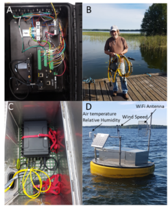
Figure 2 Modular design and testing at Erken Lake
Once this design and testing phase was completed, the next challenge was to bring the electronics from Sweden to Spain. To do this, we opted for a modular design that was easily transportable (see Figure 2), consisting of an airtight case with external connectors for the different sensors. We refer the reader to the Deliverable 2.1 for more technical details on sensors and electronics available.
The SMARTLAGOON buoy has an innovative communications system based on LoRa technology, developed by the UPV, which allows long distances to be reached, in this case about 12 km, with very low energy consumption and a proprietary infrastructure. In addition, the electronics had to be installed in an oceanographic buoy that complied with the International Association of Marine Aids to Navigation and Lighthouse Authorities (IALA) standards for Ocean Data Acquisition Systems (ODAS). For this purpose, a buoy was purchased from the company OSIL, supplied by DC Servicios Ambientales, S.L. (see Figure 3). This buoy, weighing more than 300 kg, was sent to the facilities of the Spanish Institute of Oceanography (IEO-CSIC) in Lo Pagán (Murcia), right on the shore of the Mar Menor. The buoy remained until last October 2022 in these facilities, where our partners from the UPV and UU were in charge of the assembly, deployment and tuning of the electronics in the Mar Menor.

Figure 3. Oceanographic buoy of the company OSIL, distributed by DC Servicios Ambientales, S.L.
It should be noted that prior to the deployment of the buoy, all the permits corresponding to the occupation of the maritime-terrestrial public domain were processed. This process, which began in March 2022, was carried out by our SMARTLAGOON partner, VIELCA Ingenieros, S.A., the current developer of the buoy.
Finally, on 14th October, the buoy was deployed at the point authorised by the MITERD Coastal Demarcation in Murcia, located in one of the deepest parts of the lagoon, the central basin, reaching a depth of up to 7 metres. The following video summarises this process https://www.youtube.com/watch?v=tsZfpNY2sl0.
Data Integration
The data from the buoy have been integrated into the monitoring system being developed by our partner from the UPV within the framework of the SMARTLAGOON project (https://marmenorsensing.com/). The raw data sent by the buoy are real-time data that are published every hour, in the absence of subsequent validation by experts, as they may occasionally contain errors inherent to the instrumentation and its maintenance. The UPV and the IEO have established an action protocol and a collaboration framework for the periodic maintenance and monitoring of the data, which is essential to be able to offer data with the best possible guarantees.
In addition to the buoy data, MarMenorSensing periodically collects very heterogeneous data sources to have a 360º view of the socio-environmental interactions of the Mar Menor. Currently, remote sensing data from the European Earth Observation Service Copernicus, meteorological data from sources such as the State Meteorological Agency (AEMET) or the Murcian Institute for Agricultural and Environmental Research and Development (IMIDA) and data from social networks such as Twitter, YouTube, newspapers and Telegram are available.
As an example of the potential of our system, the latest episode of high Chl-a concentrations detected in the Mar Menor between 8 and 12 November 2022 (see Figure 4). Specifically, values above 10 µg/l have been reached in the records of the Chl-a variable.

Figure 4. Chlorophyll-a levels measured by the SMARTLAGON buoy
By spatially analysing the origin with satellite sources, a direct relationship has been detected with the images extracted from SENTINEL 2 during that time interval, confirming a correlation between the data generated by the buoy.
Video –> YouTube VIDEO
Finally, social networks can identify people’s complaints related to spills in the Mar Menor. Figure 5 shows that there is an anomalous growth in the number of messages about spills before the event, indicating a potential “cause”. After the event, the possible consequences of the event are detected in more influential media such as journalistic sources.

Figure 5. Chlorophyll-a levels compared to numbers of Twitter and RSS messages.